The Bitterroot River flows northward towards Missoula and pretty much parallels Hwy 93. The most commonly floated area of the Bitterroot is from Hannon Memorial south of Darby all the way downstream to the confluence with the Clark Fork just west of Missoula. There is some floating to be had on the West Fork of the Bitterroot as well, but this tends to be seasonal due to hatches and water levels. Although this river doesn't have any of the rapids associated with either the Clark Fork or the Blackfoot, we all consider this to be the most dangerous river we float. Due to the sandy, cottonwood river bottom, the river course is always changing and carving new channels. The overall calm character of the water and the fact that in general, it's not very deep, can lull you into complacency, but on none of the other rivers do you have the constant and very real threat of, sudden, new and unavoidable obstacles appearing before you. If you dump into a set of rapids, they'll eventually spit you back out, a logjam won't. This river is full of sweepers and logjams. BE ALERT!
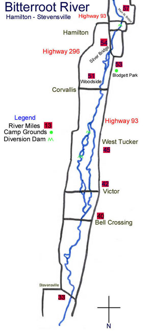
1) From Hannon to Darby is about a 6 mile float that is pretty straight forward and has both a nice launch and takeout that are suitable for driftboats. There isn't much to worry about here other than staying alert for sweepers. If you extend the float to Wally Crawford/Como, the drift becomes 11 miles of excellent trout water. There is one diversion dam that's a non-event just a ways past the Darby Bridge/access. You can almost always just run right over the top of this obstacle without getting out of the boat. The takeout at Wally Crawford is on the left just upstream of the metal bridge. The water is moving fast here, so be on the left, ready to hop and hold the boat once you see the bridge Map
2)Wally Crawford to Angler's Roost/ Hamilton: This is another long float of about 9 miles. There is a serious diversion dam in the middle of this float that you'll need to portage either your raft or driftboat around. The portage is pretty much downhill so if you have a couple of guys, it's a doable float in a hardboat. The takeout is at the Angler's Roost store immediately to the right after going under the only highway bridge you'll come across. This is private property, but if you go in and register in their book in the morning, you can launch or take out there free of charge. Map
3)Angler's Roost to Main St. Bridge, Silver Bridge, Blodgett Park or Woodside: A nice launch site at Angler's allows you to choose between 4 take outs . . . sort of. Hard boats are not an option at the Main St. Bridge, and even in a raft, you'll be doing some dragging to get your boat up the hill. This is a better option for personal watercraft such as pontoon boats. The Silver Bridge is the main bridge you cross on Hwy 93 when first entering Hamilton from the North end of town. You can winch either a hardboat or a raft up the right side bank just upstream of the bridge. It ain't pretty, but we do it often. Depending on whether the Blodgett channel is obstruction free (which it sometimes isn't), the Blodgett takeout is easy for all kinds of boats. You'll want to inquire about this channel before you float. If that channel isn't open, you can stay right provided there's plenty of water, and bypass Blodgett taking you directly to the cement boat ramp at Woodside/Corvallis. There are a couple of other things to be aware of here. About 45 minutes after you launch at Angler's, you'll be faced with a major fork in the river. For the past couple of years, either fork was a viable option, but on some years, one of both of these forks will become blocked with logs, etc… so make sure you check to see what the latest is on that situation. There is also a nasty, boulder, diversion dam between the Main Street Bridge and the Silver Bridge that, in the last few years, has been made unfloatable. This causes you to have to do a fairly obnoxious portage on the right side of the river. Keep this in mind, especially if you're using a hardboat. Map
4) Woodside to Tucker West: This is about a 6 mile float with nothing out of the ordinary to worry about other than sweepers and logjams. Where the Tucker east and west channels split, there's a new diversion dam that is generally runable and if not, due to low water, easily hand lined. Avoid the Tucker east channelMap
5) The Victor access is fine for a raft, ok for a hard boat if you don't mind the smell of melting gel coat (you have to push the boat down a rip rap bank). You throw the boat in on the southeast side of the east bridge. Map
6)Tucker West to Bell Crossing or Stevensville: The float from Tucker to Bell is only about 5 miles, but it's great water. The last couple of years, there have been some obstructions just below Tucker which have necessitated portages, but nothing too intense and nothing that excludes driftboats. If you continue past Bell Crossing and go on the Stevensville, the float becomes a long 12 miles, which becomes MUCH longer as the season gets later and water levels/speeds drop. All of the accesses are very easy here and driftboat simple. Map
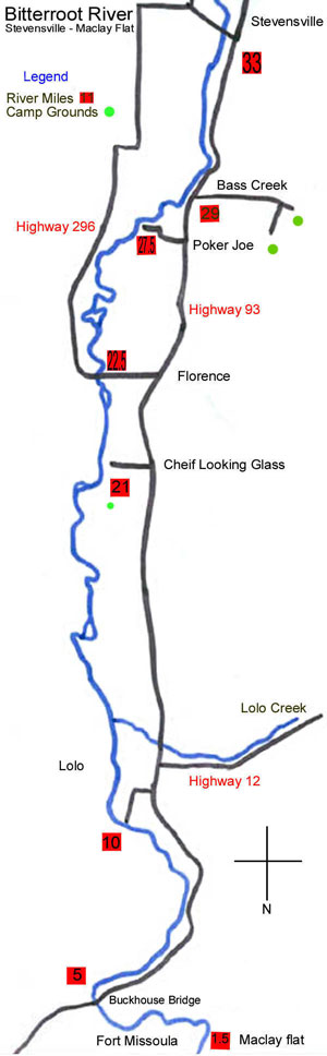
7)Stevensville to Florence: This is a nice, long float of about 11 miles. Pretty much a straight forward piece of water with opportunities at big fish. The launch at Stevensville is on the east side of the river just below the bridge, while the Florence take out/launch is just upstream of the Florence Bridge on the left. Both are easy access for all types of boats. Map
8)Florence to Lolo: This is great water, but another long float (13 miles) with a really crappy takeout that involves portaging your boat about 200 yards to the parking lot. Map
9)Lolo to Fort Missoula: This is a great stretch of water but is much different from the rest of the Bitterroot as a whole. The river broadens, shallows and slows to spring creek type situations and pretty much follows the highway the entire drift. The takeout is on the right side, in a backwater slough, about 20 minutes after you go under the black, metal highway bridge towards the end of the day. Map
10)Fort Missoula to Kelly Island or Kona Bridge: The float to Kelly Island is about 3 miles long, and you end up having to pull your boat up the Kelly island channel to get to the boat ramp that is actually on a braided channel of the Clark Fork that dumps into the Bitterroot just below McClay Bridge. Mid and late season, this isn't a problem, but when flows are heavy, getting a boat up that channel is a real pain. If you extend the float to Kona bridge, you end up having about a 9 or 10 mile float and using the Kona Bridge takeout that's described on the Clark Fork write-up. The Bitterroot and Clark Fork rivers converge just below the Kelly Island channel. Map
Major hatches: Skwala stoneflies, nemoura stoneflies, capnia stoneflies, salmonflies on the West Fork, PMD's, green drakes, hoppers, caddis, mahoganies, tricos, blue wing olives.